


GIS is hailed as one of the most effective tools for understanding the world around us. The popularity of GIS stems from its versatility; farmers can use GIS to plan their crops, realtors can use GIS to analyze market trends, government entities can use GIS in city planning - and its applications don’t end there. By providing a complete view of an area, GIS helps people in virtually any industry make smarter business decisions. While Land id® (formerly MapRight) makes GIS technology accessible to everyone, you need to know how it works to get the most out of this tool.
What is GIS?
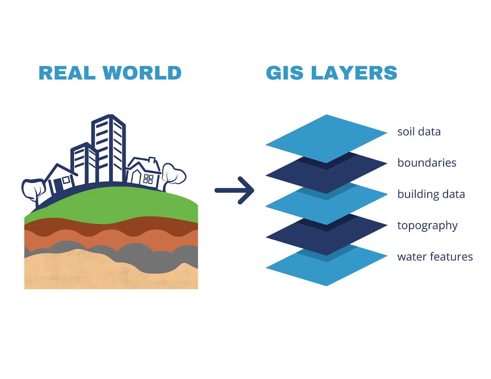
Before diving into the major components of GIS, it’s essential to understand what GIS is. A geographic information system, often abbreviated to GIS, manages, analyzes and visualizes geographically referenced information. The crux of GIS is that the information, gathered from numerous sources, is tied to specific locations. This allows us to paint as complete a picture as possible of the area so that we can more readily understand important patterns and relationships.
The Major Components of GIS
Hardware
Hardware, in simple terms, is the computer on which GIS operates. The computer running GIS will also require a central processing unit (CPU): a small chip that controls software execution, often referred to as the ‘brain’ of a computer. Beyond a CPU, GIS hardware can be broken into two major categories: input devices such as keyboards, disk drives, and digitizers (devices for converting hard-copy data to digital data), and output devices such as screens and plotters.
You may know disks as the symbol for ‘save’ on Microsoft, but a disk is also one of the major components of GIS hardware. Disks are flat, circular, magnetic devices that store information from a computer. They can be either floppy or hard, and they can store data permanently. Today, many computers don’t need disks, but they are an essential piece of hardware when working with GIS.
Another hardware component is the monitor. Also known as a screen, the monitor is the piece of a computer that displays information and results. While the monitor doesn’t have all that much to do with gathering and analyzing data, without one, we’d have no way to view our findings.
Though they aren’t crucial for GIS to run, plotters are another piece of GIS hardware that you’ll utilize in most situations. A plotter is a device that prints images or vector graphics from a computer. In recent years, traditional plotters have been largely replaced by wide-format inkjet printers. While those printers aren’t technically plotters, many people in the industry have started referring to all large printers as such.
Software
GIS software is where the real magic happens, as it’s what drives the hardware. Software is a program of code that tells a computer what to do; it’s the instructions for the CPU to execute. GIS software is vital for storing, manipulating, analyzing and displaying GIS data.
There’s no shortage of GIS software, from commercial to proprietary to open-source software - the options are endless. The key to finding the right software solution is finding what works for you. Some software applications are more user-friendly than others, which is a feature to seek out if you’re new to GIS. Other capabilities that are important for GIS software include data capture, data management, and data analysis.
Data
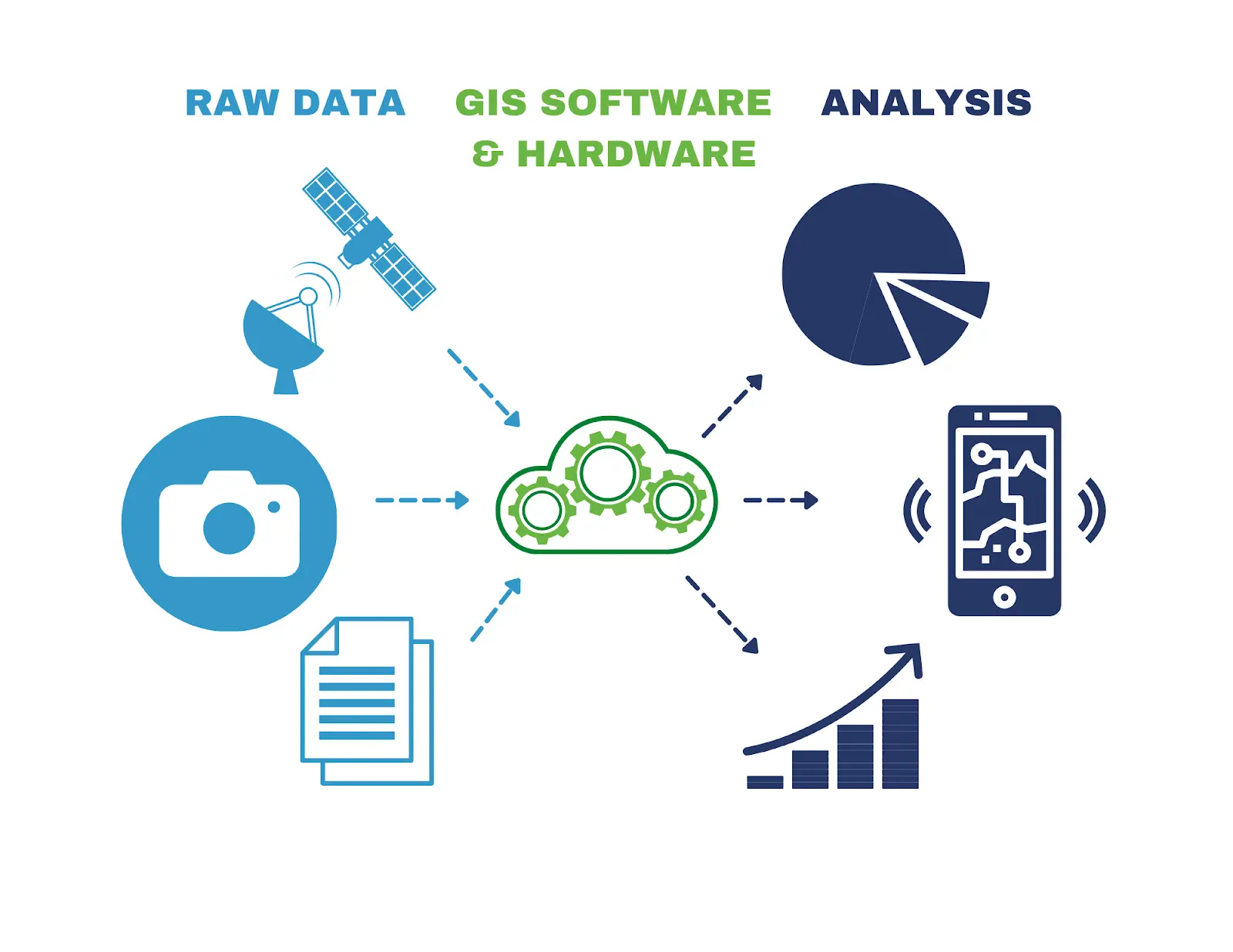
Data is hands-down the most important of all the components of GIS; everything else is centered around it. Any information that can be tied to a specific location can be included in GIS data. The most common way to collect data is by purchasing it from a data provider, but you can also gather information yourself. GIS requires massive quantities of information, so most software will include a database management system (DBMS) to control and organize the data.
The main difference between geographically referenced data and other forms of data is that GIS has the power to describe both the location and its characteristics. Spatial data describes the feature by its exact position on the Earth’s surface, typically with either raster or vector models. Raster data represents the feature in a grid of pixels, and vector data represents a feature with point and line segments, creating a polygon. When deciding how to best map the data components of GIS, it can help to remember the adage, “raster is faster, but vector is corrector.”
The final piece of GIS data, though equally important, is the attribute data. Attribute data describes the feature with information beyond location, such as a building’s name, when a feature was built, demographics of an area, and who owns the land. There’s no limit to the amount of attribute data a single feature can have.
By combining these two types of data, we get a more holistic picture of an area, which can be used to better understand patterns and relationships in the world around us.
Putting the Components of GIS Together
Once the components of GIS come together, we start cooking with fire.
Let’s begin with the data. Hard-copy data, such as deeds, documents, and photographs, can be uploaded to the GIS application through hardware, i.e., digitizers and scanners. Digital data, such as spreadsheets and database information, can be uploaded to the GIS software directly.
When the components of GIS come together, they display seemingly unrelated information with visuals that allow for novel analysis and new understandings. With Land id®, this takes the form of a multilayered, user-friendly, interactive map. What layers can you include? Almost anything: soil reports, water features, property lines, school districts, city data, flood plains - just to name a few options.
Ready to get started? Start a 7-day free trial today!
FAQs
Continue Reading
Craig Rowe
How Factory-Built Housing Can Reshape America’s Housing Market
.png)
By Land id
The U.S. housing industry’s decade-plus-long inventory challenge could see its first true sign of resolution should the 21st Century Road to Housing Act become law.

Craig Rowe
Can Refurbishing Schools Help Solve Housing Issues?
By Land id
Old public schools are becoming apartments as enrollment drops. See why school-to-apartment conversion is adaptive reuse's fastest-growing niche.


Explore Private Parcel Data & Property Boundaries
Download the Land id app and try for free.
