

On September 4th, 1882, Thomas Edison permanently altered history. Late afternoon in lower Manhattan he flipped the switch on the Pearl Street Station’s generators, and thus, the electric grid was born. In those days, we did not have the slightest of clues what the future of energy looked like, all we knew was that something revolutionary had occurred - and we were right. Today, the grid supplies electricity across the nation, powering everything from homes, to factories, to electric cars.
60% of this electricity comes from fossil fuels, 20% from nuclear energy, and 20% from renewable energy sources. However, renewables have the potential to contribute far more than they currently do. In fact, the EIA predicts that we will see renewables supply over double what they currently do by 2050 - but it will not be easy. The electricity grid is not yet equipped to handle renewables in the quantity we require, but we can get there with the help of grid mapping software.
How The US Energy Grid Works
The US energy grid is the infrastructure that generates electricity from centralized power plants, transforms it into usable forms, and carries it to us, the consumer. All electricity, regardless of whether it comes from fossil fuels, nuclear, or renewable energy sources, has limitations. For instance, energy cannot be stored in large quantities; the electricity must be created as it is used - barring disaster, the grid is always running. Advances in battery and other storage technologies are being rapidly developed and deployed, clearing a path to a smarter grid.
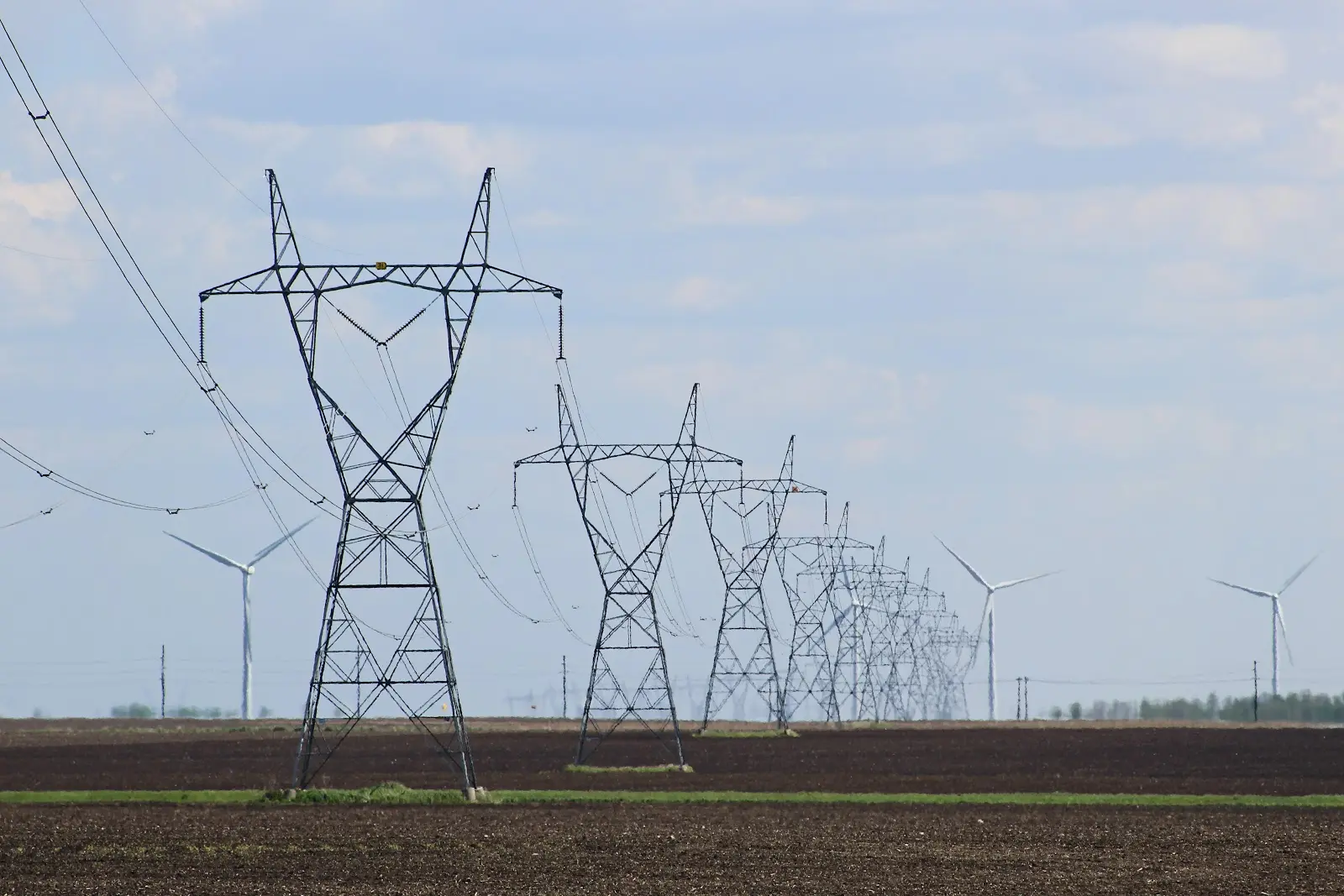
Transmission
Electricity is carried through wires, which presents a small issue; wires create resistance, causing some of that electricity to be lost - and the further the electricity must travel, the more energy we lose. To fix this issue, once the electricity has been generated at a power plant, it travels directly to a step-up substation where it is converted into a higher voltage. This lowers the resistance, allowing the energy to travel long distances with minimal losses. After the voltage is stepped up, it flows through transmission lines (high voltage power lines) until it reaches its next destination.
Distribution
Eventually, the electricity will reach the end of its journey through transmission lines and enter another substation. This substation, however, is tasked with stepping down the voltage. Transmission lines carry electricity at a voltage of around 11,000 volts, but the next set of power lines the electricity will flow through, distribution lines, only carry electricity at around 220 volts. Once the voltage is lowered to a safe point, the distribution lines take the electricity and deliver it to homes and businesses where it is consumed.
Infrastructure Barriers To Renewables
Fossil fuels and nuclear power are highly centralized; they can get by with a small number of high output plants, typically located far away from the consumer. Wind and solar, however, utilize a decentralized method of energy generation; they are generated by many smaller plants.
Siting
The first issue this decentralized model presents is with the siting; finding locations suitable for wind and solar farms. To start, solar farms need at least four peak hours of sunlight every day, which can be difficult to find; the location cannot have too many buildings or trees blocking the light, too extreme a slope, or climate conditions that do not offer year-round sunlight at the intensity needed. And not only does the land need to be well-suited for sun exposure, it also needs to be far away from protected wetlands and large enough to house the panels. Solar farms can range drastically in size, but community solar farms typically need a minimum of five acres (usually more), while utility-scale solar farms tend to need at least 30-40 acres of land.
Like solar farms, wind farms cannot be in protected areas, and they require a good deal of space. The consensus is that they need to be positioned seven rotor diameters apart, but some researchers have found that they are most effective at about double that distance. Either way, wind farms need a lot of land (though the land between turbines is still usable). And of course, wind farms also need wind. Most wind turbines need a minimum of 10 mile per hour wind speeds to begin working, which is easier to find in cooler climates with dense air. However, it is a balance; the area cannot get too much ice, as it can present a safety hazard for the people and infrastructure nearby.
How Grid Mapping Software Can Help
Finding spots with just the right conditions can be difficult; there are a lot of competing factors to consider. However, grid mapping software makes this task far more manageable. With Land id® (formerly MapRight), clients can add a layer for topography to ensure the area has a suitable slope, water features to prevent building on protected wetlands or floodplains, and land use to help determine if the area is even an option. But of course, there are also climate conditions to consider, so users can import GIS data for temperature, sun exposure, and wind speeds as well. By layering each relevant condition onto a single, interactive map, grid mapping software makes viable locations far more apparent.
Transmission
The next issue the decentralized model presents for renewables is with transmission. Excess electricity cannot be stored, yet there are some instances where wind and solar farms produce far more electricity than they need, and some instances where they do not produce enough (like during the night or on a windless day). Luckily, technology is catching up. Smart grids, which allow for a two-way flow of electricity, can largely solve this issue by intelligently sending the energy where it is needed.
However, storage is not the only transmission issue. Wind and solar farms are not often suited for the same locations as traditional power plants are, and currently, most of the electricity infrastructure is centered around those plants. A significant part of the problem is cost; building all new infrastructure to support renewable energy is a pricy feat - new 69 kV overhead single-circuit transmission lines cost around $285,000 per mile. That being said, it is worth the investment. Wind and solar energy are extremely inexpensive to operate once they’re up and running, and the economic benefits are immense - there is a huge ROI in green energy.
How Grid Mapping Software Can Help
Transmission is another area where grid mapping software will come in handy; by adding a layer for transmission lines and substations, finding suitable locations for renewable energy is made far easier. With Land id’s grid mapping software, clients can instantly view every major transmission line and substation across the nation. Plus, the layers also show critical data such as the name, owner, voltage, and status.
However, one of the main issues with transmission is a lack of infrastructure. Not only can grid mapping software help source locations for wind and solar farms, but by pinpointing where the infrastructure already exists, professionals can easily spot areas that need new construction.
Get Started With Land id®
The electric grid is getting greener, and Land id® has all of the tools professionals need to get in on the action. With Land id’s grid mapping software, in addition to identifying substations and transmission lines, you can add a layer for virtually any condition that could impact the viability of wind and solar farms: topography, parcel size, land use, protected lands - you name it. Want to be a part of the renewable revolution? Start your 7-day free trial of Land id® today!
FAQs
Continue Reading
Craig Rowe
How Factory-Built Housing Can Reshape America’s Housing Market
.png)
By Land id
The U.S. housing industry’s decade-plus-long inventory challenge could see its first true sign of resolution should the 21st Century Road to Housing Act become law.

Craig Rowe
Can Refurbishing Schools Help Solve Housing Issues?
By Land id
Old public schools are becoming apartments as enrollment drops. See why school-to-apartment conversion is adaptive reuse's fastest-growing niche.


Explore Private Parcel Data & Property Boundaries
Download the Land id app and try for free.
