

We’ve been using maps to better understand our world for millennia, and from the very beginning, the goal of cartographers has been to represent the data as clearly as possible. Cartography, or the science of map making, allows us to analyze positional relationships, examine how geography affects our lives and see how we fit into our surroundings.While the goal of map makers is to display information as definitively as possible, maps will still reflect the intention of its creator. If you're a farmer, your purpose for property mapping will differ from that of an environmental conservation foundation or the US military. For that reason, there is more than one way to map the land. Do you want to see the elevation? The plant-life? The soil? Air quality? Aquifers and water features? Or maybe, parcel data?From our ancestors mapping out the night sky on cave walls to our own use of GPS to find the nearest Italian restaurant, maps have been integral to the exploration and understanding of our existence. There are innumerable reasons to create a map, and the methods and tools we have developed over time reflect this desire to illustrate different perspectives.
The Methods and Tools of the Trade
Nowadays, the process of property mapping can be done in a number of ways to provide you with different types of data that provide unprecedented insight into aspects of your land, both above and even below the surface of the earth.
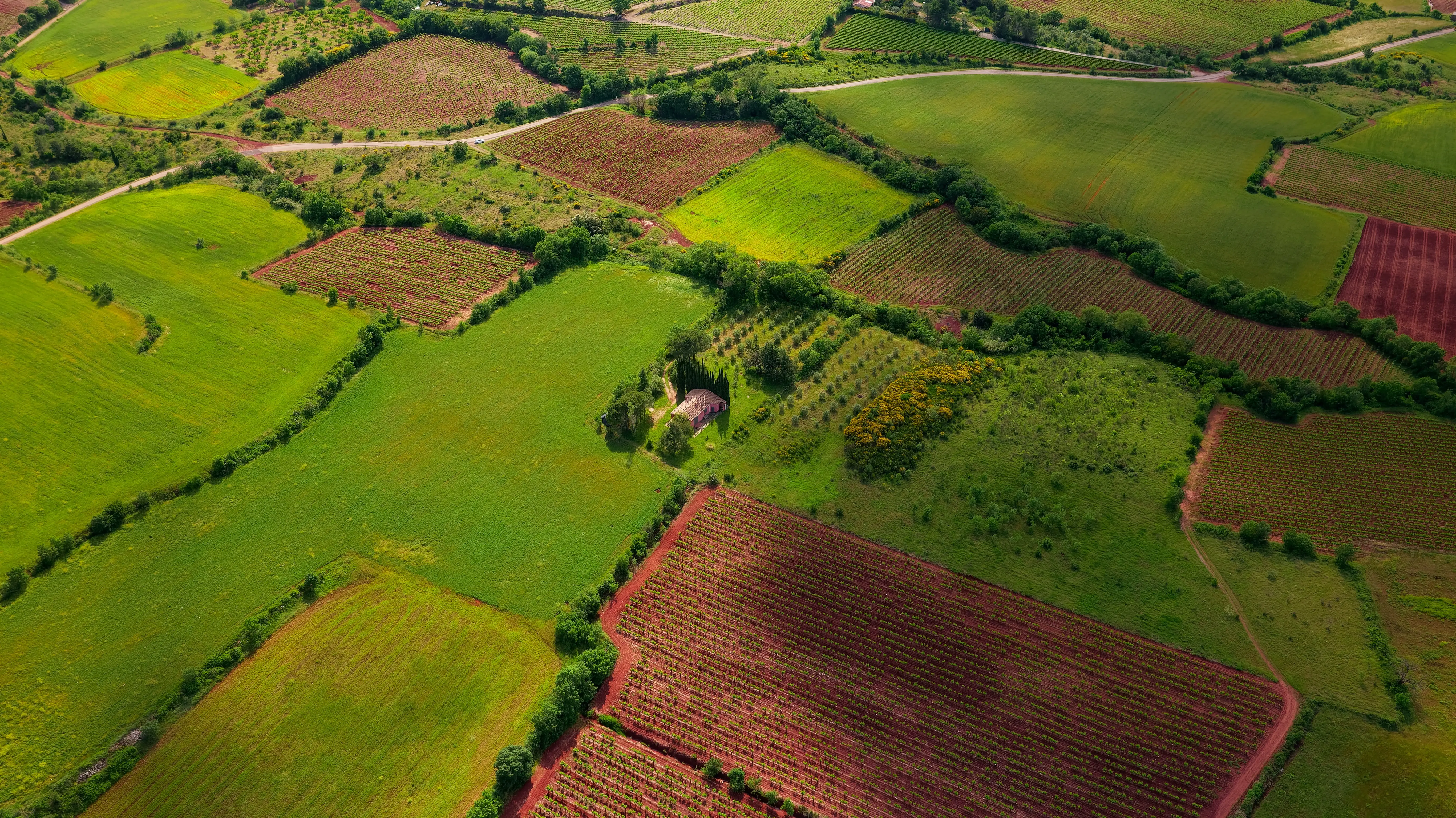
Aerial Photography: As the Eagle and the Wild Goose See It
Aerial photography is exactly what it sounds like: the taking of photos from an aerial perspective using an aircraft or some other flying object. People have been trying to get cameras in the sky since before the Civil War. However, the oldest surviving aerial photograph was taken in 1860 and titled, 'Boston, as the Eagle and the Wild Goose See It.'Since then, people have used a whole host of different vehicles to get cameras in the sky: helicopters, unmanned aerial vehicles or drones, balloons, blimps, rockets, pigeons, kites, parachutes - essentially, if it flies and you can attach a camera to it, someone has probably tried it.For use in property mapping, there are several different types of aerial photography. You have oblique photos, which are taken at an angle and show an expanse of land. You have vertical photos which are taken from straight down and usually use a large format camera to capture a large area. Vertical photos are often used in photogrammetry. And lastly, you have orthophotos, which are photos that have been orthorectified, or corrected, so that the scale is uniform and the photo can be used as a map.The advantage of employing aerial photography to map your property is that it gives you a real-time, large-scale record of your land. Compared to using satellite imaging, aerial photography will provide better resolution, a higher degree of detail and avoid obstructions caused by atmospheric conditions.
Sensors: More Than Just a Picture
Sensors detect stimuli in a given area, such as sound, light, temperature or movement, and convert it to electrical signals in order to measure events, changes and other characteristics of the environment. Sensors have been around for a while in rudimentary forms (think wind vanes or thermometers), and these days they’re sophisticated enough to detect something as small as antibodies in your blood. Of course, for the purposes of property mapping, you won’t likely need something quite so sensitive.You can use equipment that employs the use of sensors in a variety of ways to collect data on your land. Anemometers measure wind speed, seismometers measure motion in the ground, bolometers measure electromagnetic radiation, microphones detect sound, thermometers measure temperature, just to name a few examples. For almost anything you want to learn about the environment on your land, there is probably a device out there designed for that purpose.Sensor-equipped technology is often used in change detection projects to see how conditions such as soil temperature change over time. They are also capable of helping you gather large amounts of data which is helpful for mapping a large area very accurately. A prime example of using sensors to map land is LIDAR, a technique named by combining light and radar. This method measures distances by shooting a laser at a target and measuring the reflection with sensors. Differences in laser return times and wavelengths are then used to make a digital 3D representation of the landscape.
Satellites: As the Stars See It
The very first satellite was Sputnik 1 shot into orbit by the Soviet Union. For a couple of weeks in 1957, it orbited the planet broadcasting radio pulses that even amateur radio enthusiasts could detect. While its batteries didn’t last long, it was able to provide data on the upper atmosphere and ionosphere. Ever since then, nearly ten thousand satellites have been launched into orbit, and an estimated two thousand are currently active today.The very first satellite might not have been capable of much, but modern satellites aid us in navigation, communication, weather tracking and forecasting, spying on our fellow man and observing earth. Satellites allow us to regularly survey the earth’s surface at increasingly faster rates, and they have large coverage areas. A satellite in geostationary orbit has uninterrupted coverage of more than one third of the Earth; with just three satellites, we can scan virtually the entire surface of the planet.Data provided by satellites has been used for property mapping in agriculture, real estate, environmental conservation, forestry and more. Geospatial data that used to take several months to gather now can be retrieved in minutes thanks to the help of satellites, and with the assistance of a GIS, this data becomes very versatile.
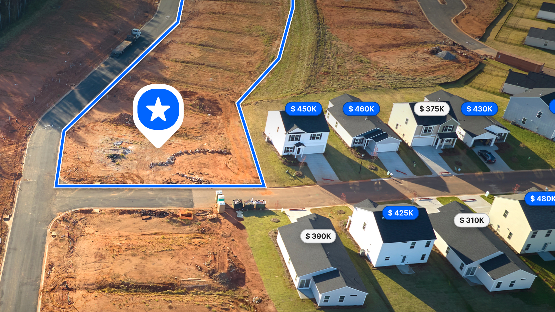
GIS: A Powerful Property Mapping Solution
Geographic information systems (GIS) are software that you can use to view, organize, analyze and manage geospatial data. While photography, sensors and satellites are all a means to collect mapping data, GIS is a framework for visualizing that data. Multiple layers of information can be transposed on top of each other, visualizing data from several different sources in a single map. Different types of information can be compared and contrasted such as property ownership and soil type, the location of water sources and population, or the location of schools and types of vegetation. In any case, the goal is to identify spatial relationships and patterns.This technology has been steadily improving since the 1980s. In fact, these days you can fit the power of a GIS into your back pocket. Land id® (formerly MapRight) makes our powerful mobile app available with each one of our subscription plans. You can access and edit your maps from any location, even when cell service is spotty. Our web application allows you to build beautiful, analytical maps using a variety of different layers, markup tools and icons.Whether you need to visualize undeveloped land or map out your natural resources, our GIS platform is designed to be easy to use and affordable for every type of user. Of all the tools you can use to map your property, we guarantee Land id® will be your favorite. Start a 7-day free trial today!
FAQs
Continue Reading
How to Price Land for Sale Using Comparable Sales Data
By Land id
Learn how to price land using comparable sales. Find, analyze, and adjust vacant land comps to price listings accurately and sell with confidence.
Craig Rowe
Can Refurbishing Schools Help Solve Housing Issues?
.png)
By Land id
Old public schools are becoming apartments as enrollment drops. See why school-to-apartment conversion is adaptive reuse's fastest-growing niche.


Explore Private Parcel Data & Property Boundaries
Download the Land id app and try for free.
