

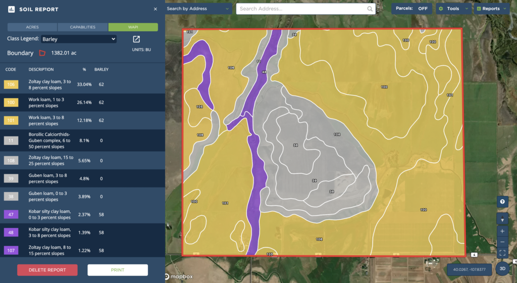
Dallas, TX — October 6, 2021 — Land id® (formerly MapRight) is thrilled to announce two crucial updates to our Soil Reports. Reports now include two new datasets, allowing users to access National Commodity Crop Productivity Index (NCCPI) ratings and Weighted Average Productivity Index (WAPI) values directly from Land id’s Soil Reports.
The NCCPI assesses soil’s ability to produce dryland crops such as wheat, cotton, sorghum, corn, soybeans and barley. The ratings are based on the soil’s properties, the landscape and the climate the soil is in. According to this method, the more desirable the soil is for general crop production, the higher its rating will be.

In contrast to the NCCPI ratings, WAPI values indicate the soil’s ability to produce a particular crop, not the productivity of the soil in general. The incorporation of this data means Land id® users will be able to find the WAPI values for dozens of different crops and see the average yields per acre that can be expected for a specific, non-irrigated crop with a high level of management.
“These new capabilities will be incredibly valuable for the agriculture industry,” says Land id®’s CEO, Steve Roberson. “With a few clicks, users will be able to assess the productivity of their land and determine which crops are most likely to succeed. Not only will farmers find this information helpful, it will be beneficial to anyone selling or buying rural land, as well.”
NCCPI ratings are based on data from The National Soil Information System (NASIS), which comprises multiple soil applications and databases. The data found in NASIS covers almost all of the nation’s farmland, and is incredibly consistent. According to the Natural Resources Conservation Service (NRCS) segment of the USDA, NASIS data is uniformly available, able to be accessed electronically, produced by the same standards nationwide, routinely maintained and highly detailed.
The average yields represented by the WAPI values are primarily determined by the experience and records of farmers, conservationists and extension agents, in addition to yield data from nearby areas and the results of field trials and demonstrations.
The NCCPI ratings And WAPI values are now conveniently available in Land id’s web and mobile applications. To see our new and improved Soil Reports, login or sign up for Land id’s 7-day free trial today!
About Land id®
Building on several decades of education and experience working with GIS, Land id® was founded in 2014 to help companies and individuals gain a better understanding of properties and land features and be able to more intuitively communicate them with others. Land id® offers nine different GIS base layers and nearly two dozen Land id® layers, countless styling and customization options, and several easy ways to share your maps. A 7-day free trial helps users get started on the web app and companion mobile app. If you’re looking for an even more affordable and compact map making experience, check out Land id’s standalone mobile app.
FAQs
Continue Reading
Craig Rowe
Prospecting, Part 3: Find Land Faster
.png)
By Land id
How real estate investors and developers can use Land id to discover and analyze land-buying opportunities in less time.

How to Price Land for Sale Using Comparable Sales Data
By Land id
Learn how to price land using comparable sales. Find, analyze, and adjust vacant land comps to price listings accurately and sell with confidence.

Explore Private Parcel Data & Property Boundaries
Download the Land id app and try for free.
