

Renewable energy projects don't fail in construction. They fail in the field, before a single permit is filed, when teams are working off county PDFs, spreadsheets, and gut instinct instead of a unified land intelligence layer.
Here's what experienced developers know about getting the land right from day one.
Key Takeaways
- Renewable resources development planning software is a pre-construction category. It's built for site screening, land control, feasibility work, and stakeholder communication.
- Modern planning tools must combine parcel data, permitting status, grid proximity, and resource quality, with geospatial visualization at the core.
- Land id provides the parcel and mapping foundation that renewable development teams rely on to find sites, secure land, and bring stakeholders along through the process.
- The global renewable energy market is projected to nearly triple between 2025 and 2033, growing from $1.6 billion to $4.9 billion, reflecting how central these tools have become to modern development.
The Real Bottleneck Isn't Energy. It's Land.
The U.S. renewable build-out is moving fast. IRA incentives have pushed annual capacity targets to 60–80 GW. NREL projects that meeting 2035 clean energy targets on federal lands alone would require up to 2 million acres. Queue backlogs in major ISOs like PJM and ERCOT already exceed 2,400 GW.
The energy isn't the problem. The land is.
Common pre-construction failure points include unsuitable parcels, community opposition that derails projects late in development, incomplete site control that creates title disputes, and misjudged environmental constraints that surface during permitting. There’s a good chance you’ve seen those items shelve a project.
Add interconnection costs that can multiply several times over for sites far from existing substations (in some regions, the gap between a well-sited and poorly sited project runs into hundreds of dollars per kilowatt), and the math on a bad site selection decision gets ugly, fast.
The developers who move fastest aren't the ones with the biggest teams. They're the ones who can screen thousands of acres in hours or days, not weeks—and rule out poor-fit sites quickly.
What Is Renewable Resources Development Planning Software?
Renewable resources development planning software refers to the digital tools that support site selection, land control, feasibility analysis, and early project design for solar, wind, battery storage, and hybrid configurations.
These are pre-construction tools. They're not asset performance management systems. They're not SCADA platforms. Those come after commercial operation date. The distinction matters because conflating these tools leads to misaligned expectations and gaps in your workflow.
Land id® is the parcel and mapping foundation—the land intelligence layer that feeds everything else in your planning stack.
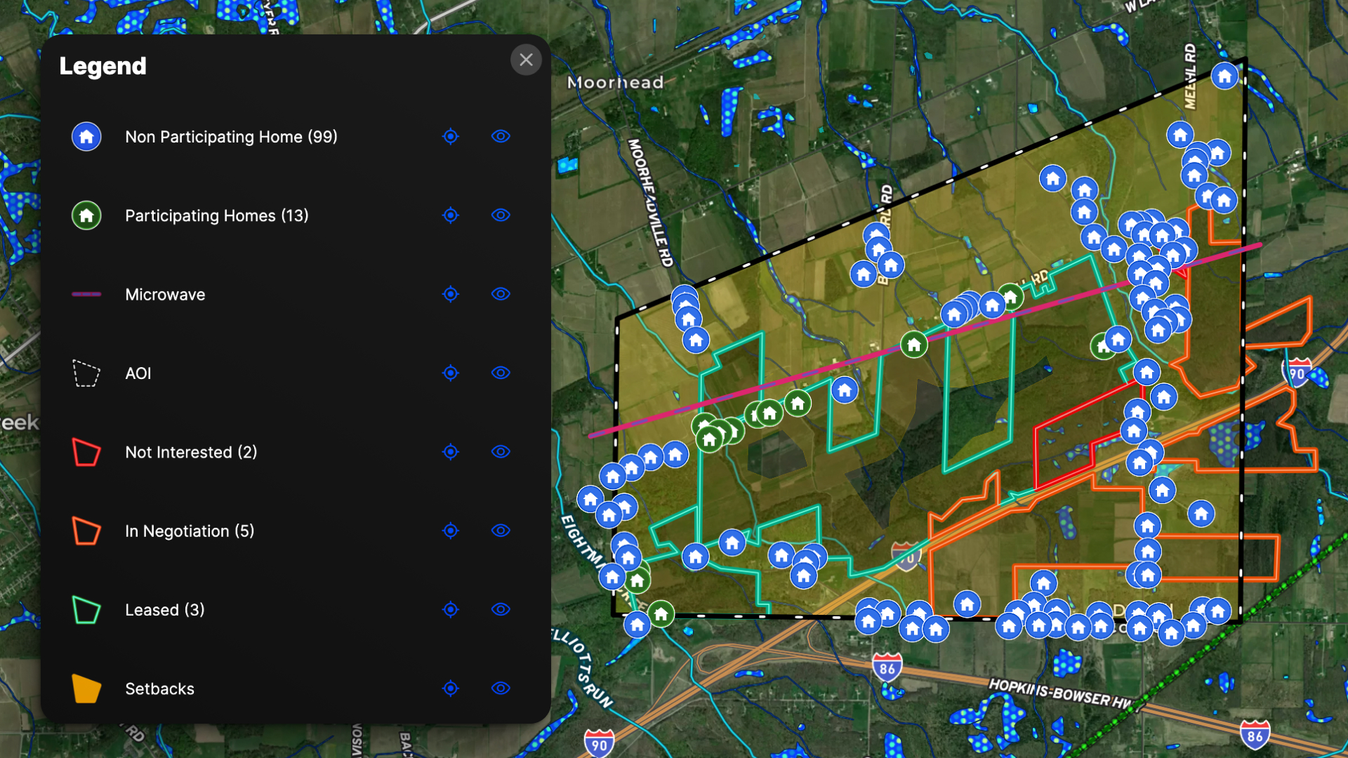
The Two Layers That Make or Break a Renewable Site
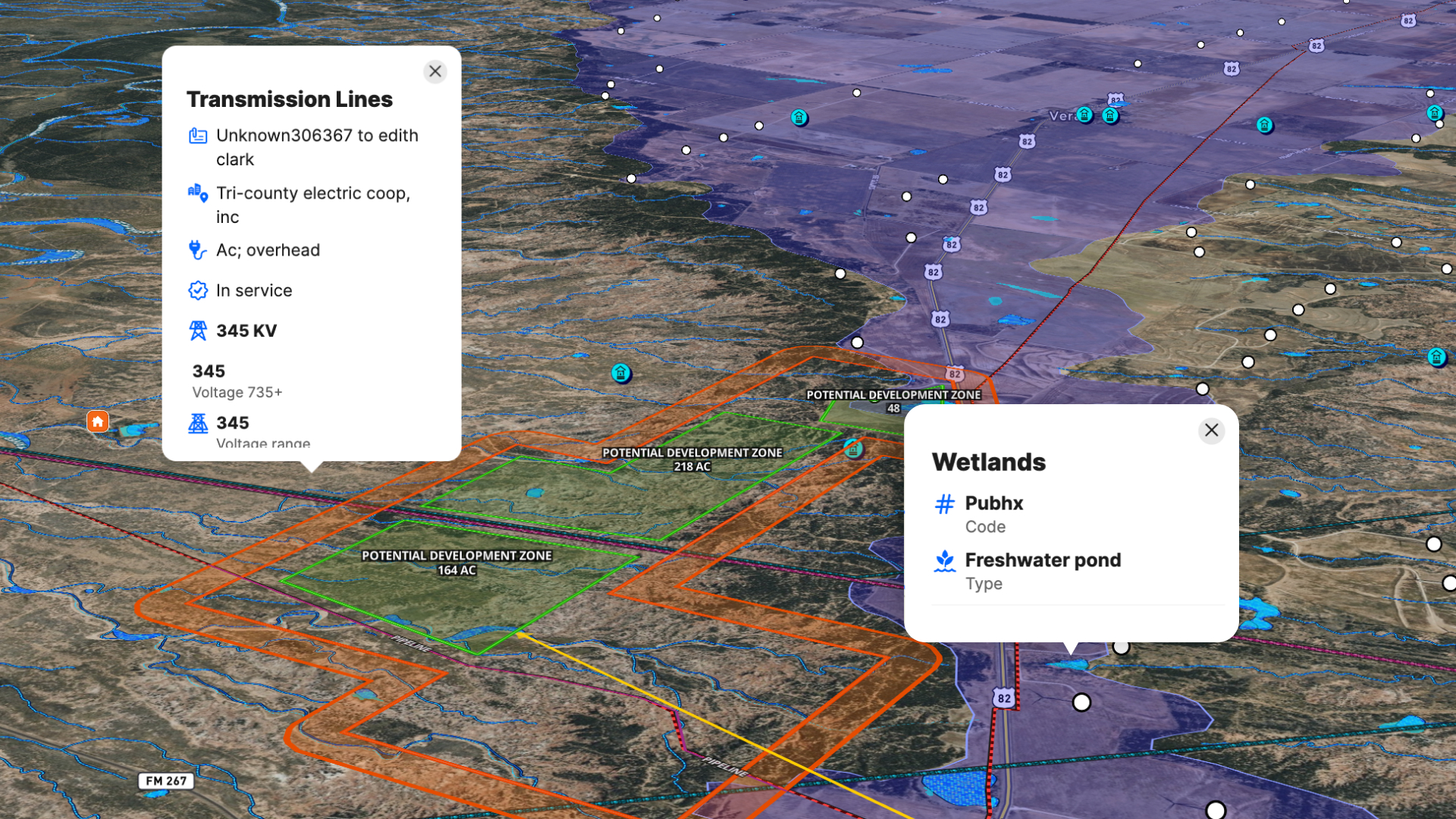
Ask any experienced greenfield developer what kills projects early, and you'll hear the same two answers: wetlands and transmission lines.
Wetlands can ruin a project. Federal, state, and county setbacks compound on top of each other, and a parcel that looks clean on a satellite image can be disqualifying once you layer in National Wetlands Inventory data. The earlier you catch it, the less it costs you.
Transmission lines determine whether a site can actually deliver power. Utility-scale renewable energy needs to connect to the grid—and getting new transmission lines approved is slow, expensive, and uncertain. Sites within a viable radius of an existing substation with available capacity are worth significantly more than sites that aren't. A rough rule: every mile of new interconnection adds roughly $1 million in cost.
Land id lets you layer both of these onto a single map—alongside flood risk, slope, soil type, conservation easements, existing wind and solar farms, and parcel boundaries—so you can see the full picture before you make a single call to a landowner.
That's not a small thing. That's weeks of research compressed into a single session.
The Four Phases of Renewable Site Development
Most site failures trace back to one of these four phases. Knowing how to use the right tools makes all the difference in each one.
Phase 1: Greenfielding—Find the Site Before Someone Else Does
The greenfielding phase is where Land id earns its place in your stack.
Start with the substation, then determine your economically viable radius. Ask, “What is the distance where interconnection costs stop making sense?” From there, you're screening every parcel inside that radius against a checklist of constraints.
For solar projects, your screening criteria look like this:
- Minimum contiguous acreage (often 500+ acres for utility scale)
- Slope under 5% for tracking systems, up to 15–20% for fixed-tilt
- Outside FEMA 100-year floodplain
- Less than 10% wetland coverage
- No prime farmland designation (or acceptable mitigation path)
- Within three to five miles of a 138 kV or higher substation
For wind projects, add:
- Adequate spacing (turbines need at least seven rotor diameters apart; 15 is optimal)
- Distance from residential structures (setback requirements vary by county)
- Migration pattern and flight path data to assess wildlife impact
- Rail line access for large component transport
In Land id, you can build a map template with all of these overlays switched on by default for every new candidate area. Drop a study area boundary on the map, and you're immediately looking at slope, wetlands, flood risk, soil type, and parcel boundaries in one view. Parcels that fail the screen get ruled out in minutes.
How to apply this:
- Define your study area around a target substation.
- Build a standard overlay template in Land id for your project type (solar vs. wind).
- Use the buffer tool to model setbacks from roads, streams, homes, and neighboring structures before you ever visit the site.
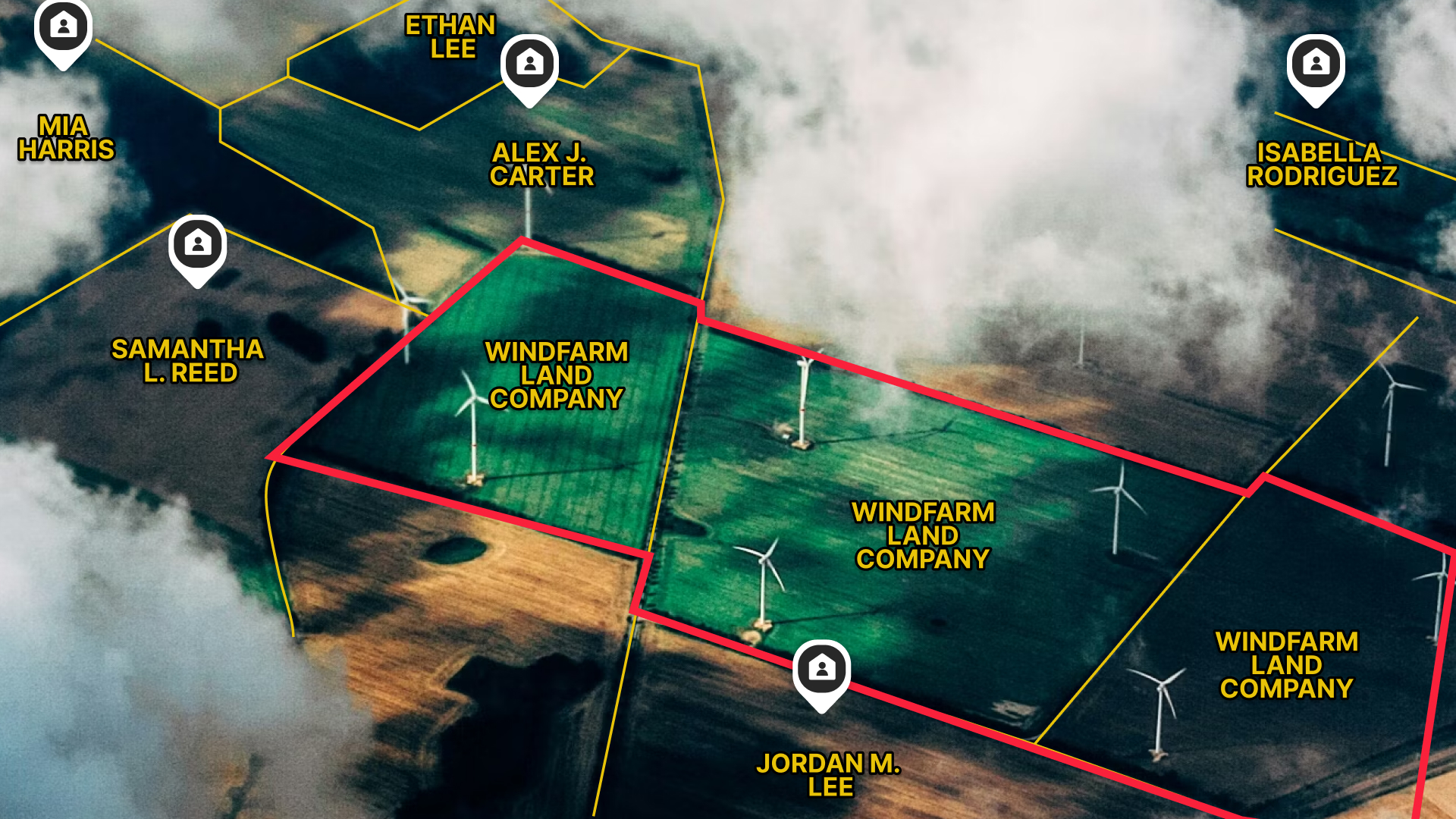
Phase 2: Land Control—Own the Relationship Before the Competition Does
Finding a viable site is step one. Controlling it is step two, and it's where deals get won or lost.
For a utility-scale solar farm, you might be assembling a contiguous 1,000-acre footprint from 20 or 30 separate landowners. Each parcel is a separate negotiation. Each owner has a different situation, a different timeline, and a different level of interest. If a competitor reaches them first, you're done.
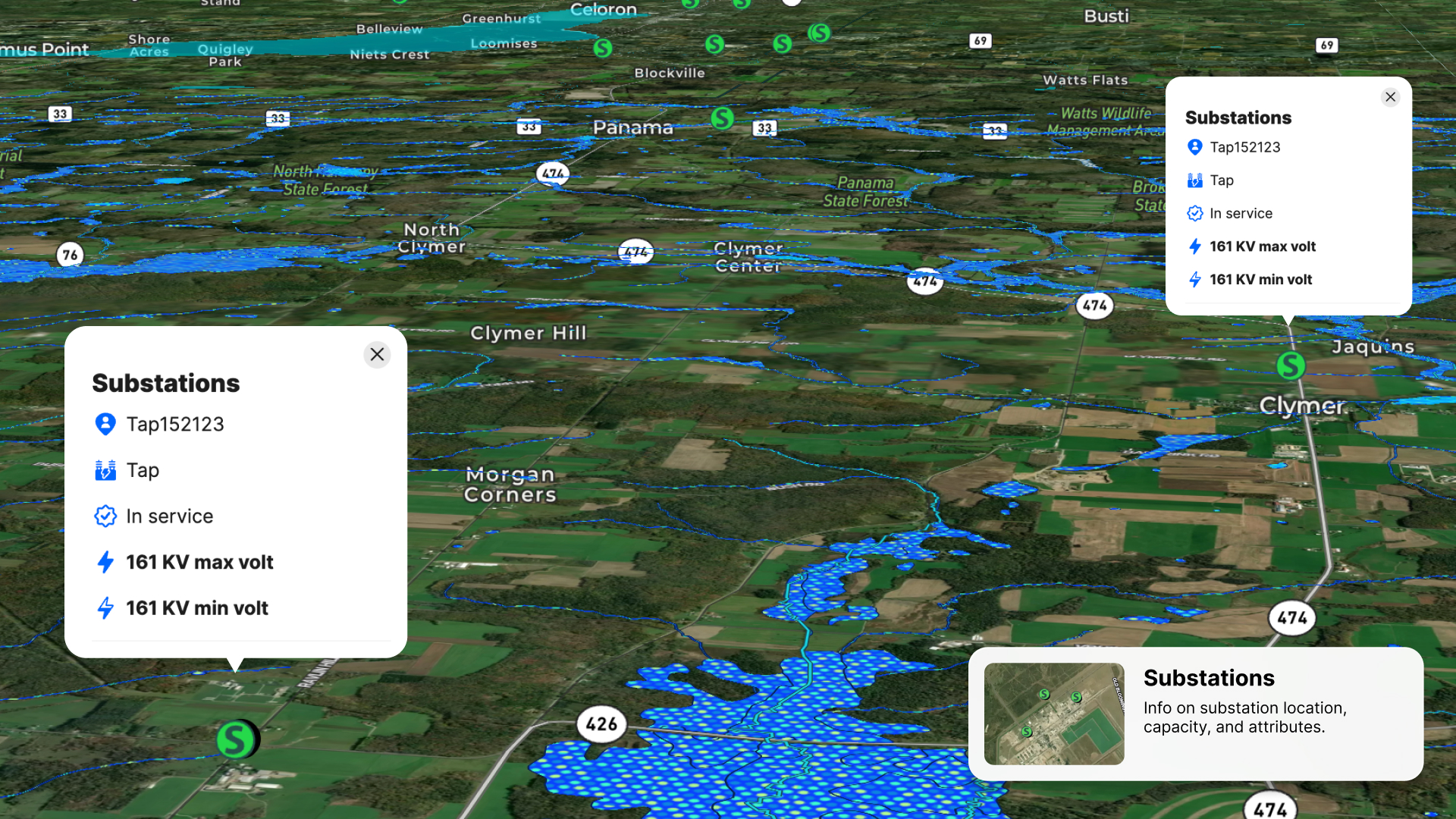
Land id gives you the ownership intelligence to move fast:
- Owner name and mailing address
- Parcel ID and legal description
- Acreage and assessed value
- Tax data by county
- Existing easements and rights-of-way
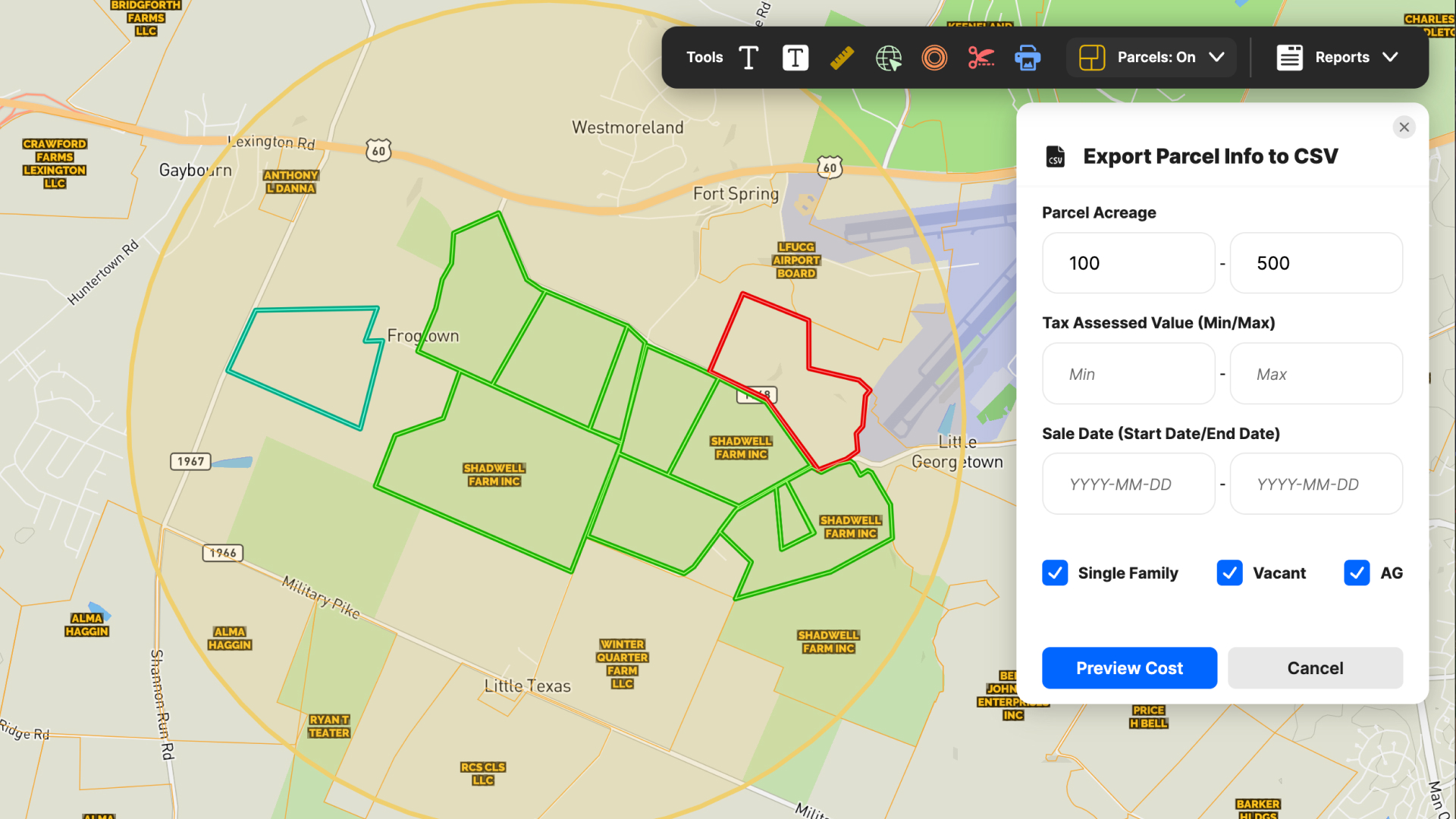
From your project map, you can select all parcels within your study area, export a landowner list as a CSV, and have your land team in outreach mode the same day. No county website rabbit holes. No manual data entry from PDFs.
The buffer tool matters here, too. Model your interconnection route from the project site to the substation, identify every parcel the route crosses, and you know exactly how many separate deals you're looking at and what each one costs you if it falls through.
How to apply this:
- Use Land id's parcel search to identify adjacent owners and build your target list.
- Export ownership CSVs directly from your project map for land team outreach (additional cost applies).
- Use the buffer tool to map your interconnection corridor and flag parcels with overlapping interests early.
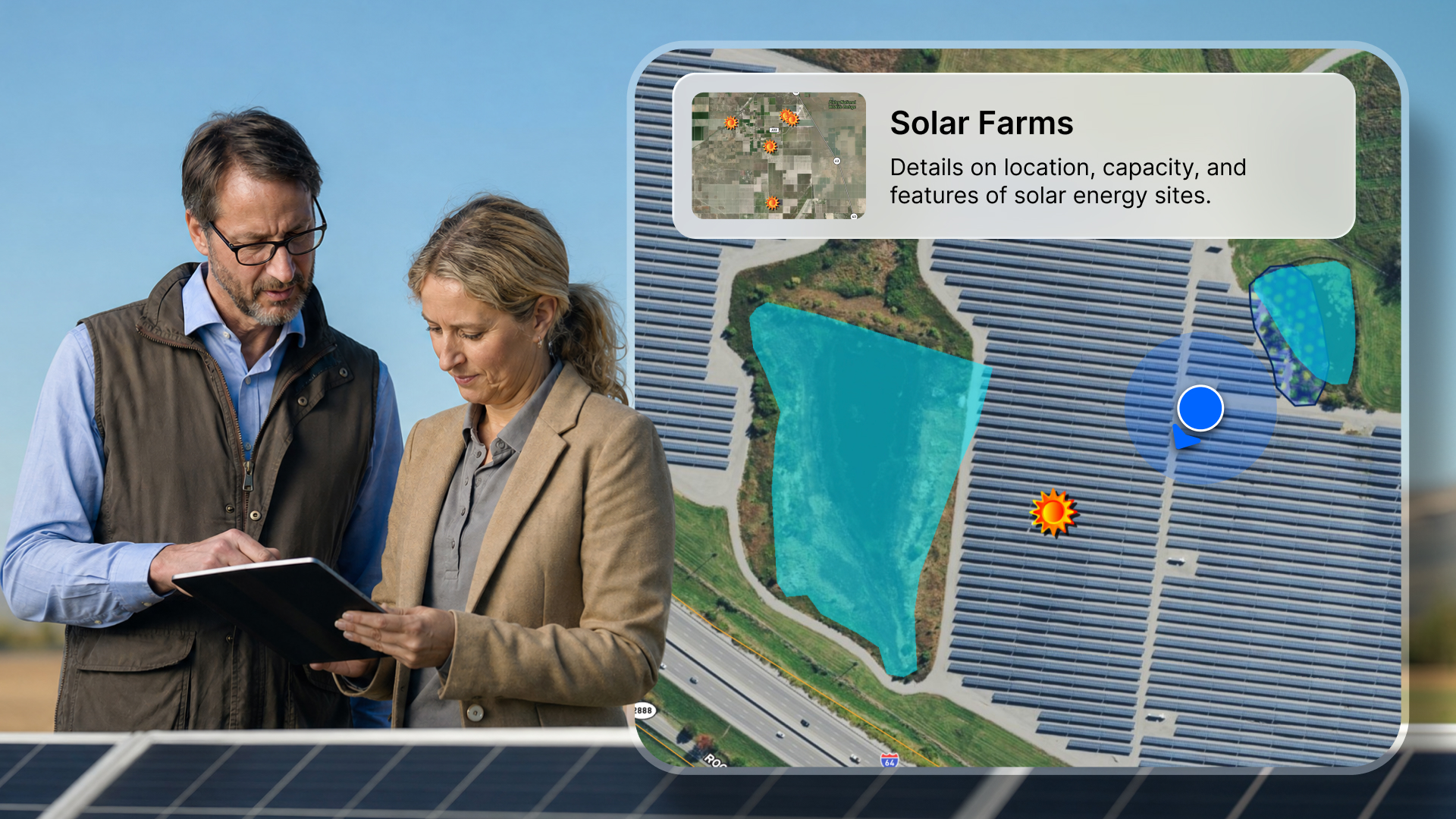
Phase 3: Stakeholder Communication—Maps That Move Projects Forward

Most developers underestimate this: they treat the map as an internal tool, but its true power is a communication asset.
You're going to use it to pitch landowners on why leasing makes sense. You'll use it in county commissioner meetings to get development approvals. You'll share it with project finance teams who need to see documented site risks before they'll commit capital. You'll hand it to environmental consultants, engineering firms, and utility contacts. All of whom need to understand the same project, from different angles.
Land id lets you create branded, interactive maps that share via a single link. For landowner presentations, you can annotate the map with proposed array or turbine locations, access roads, laydown yards, and buffer zones, giving the owner a visual picture of what the project looks like on their land. That's a more compelling conversation than a spreadsheet.
For county meetings, a clean, professional map with labeled setbacks, environmental constraints, and project boundaries communicates competence. It shows you've done the work.
How to apply this:
- Build a single "canonical" project map that updates as parcels are added or dropped.
- Use annotations to show proposed layouts, setbacks, and access routes for landowner conversations.
- Share via link for finance, legal, and environmental teams—no more emailing static files.
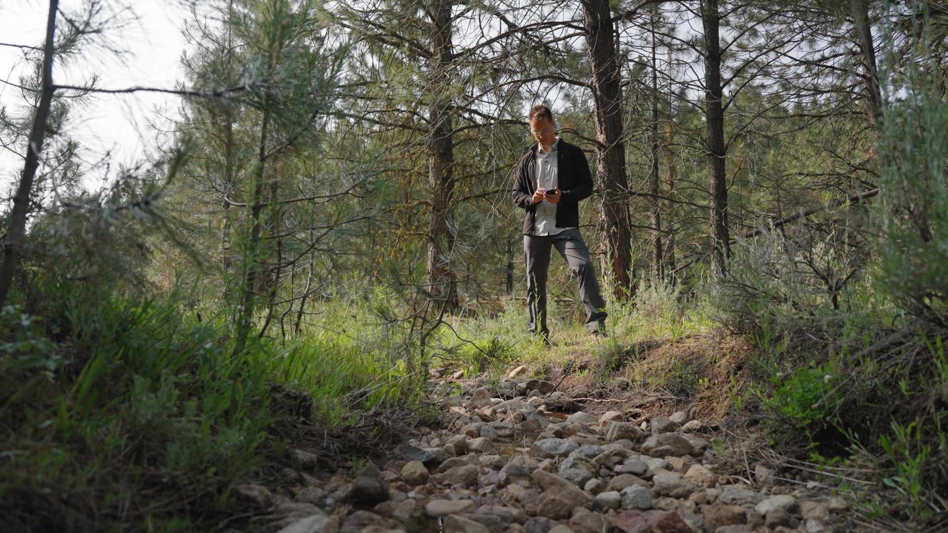
Phase 4: Field Work—Ground-Truth the Map Before You Commit
No map replaces a site visit. But a good map makes the site visit dramatically more productive.
Land id's mobile app lets you take your project map into the field, even in areas with limited connectivity, which describes most rural solar and wind sites in Texas, Montana, or the Dakotas.
- Walk property lines to verify boundaries.
- Confirm access points and road conditions.
- Capture photos and attach them directly to map features.
- Document turbine setbacks or panel laydown areas on the ground.
When you're back in range, everything syncs to the web app. Your office-based team sees what you saw, attached to the exact location where you saw it.
This matters more than it sounds. A parcel that screens clean on paper can have a drainage issue, an access problem, or a neighbor situation that changes the calculus entirely. Catching that in Phase 1 costs you an afternoon. Catching it in permitting costs you months.
How to apply this:
- Download offline maps before heading to rural sites.
- Use waypoints and notes to flag issues directly on the map during site visits.
- Attach photos to specific parcels or features so your team has full context without making the trip themselves.
How Land id Fits Into Your Broader Planning Stack
Land id handles one part of the renewable development workflow: land and parcel intelligence. It's designed to work alongside the rest of your stack, not replace it.
The handoffs look like this:
- Site boundaries from Land id → imported into PVSyst or Windographer for energy yield modeling
- Parcel ownership lists → exported as CSV for CRM integration or land management workflows
- KML or shapefile exports → handed off to engineering firms for CAD drawings and utility submission packages
- Annotated project maps → shared with environmental consultants for constraint review
The global renewable energy software market is projected to grow from approximately $1.6 billion in 2025 to $4.9 billion by 2033. That growth reflects a simple reality. The complexity of the current build-out cycle requires purpose-built tools at every stage of the development process. Land id owns the earliest, most critical stage. Where projects are won or lost before most of the industry even knows they exist.
Getting Started: What Your First Renewable Development Map With Land id Looks Like
You don't need a GIS department to get value from this platform. Most developers with basic mapping familiarity are productive within a single session.
Here's a practical onboarding sequence:
- Pick one pilot region—a single substation radius or target county.
- Build your standard overlay template—flood risk, wetlands, slope, soil type, and transmission lines switched on by default.
- Define your Phase 0 screening criteria—minimum acreage, max slope, substation proximity, wetland threshold.
- Run your first candidate list—pull parcels, apply overlays, rule out the obvious misses.
- Export your first landowner list—get your land team into outreach mode.
From there, layer in more advanced workflows: multi-user collaboration, standardized templates across your pipeline, geo-referenced CAD overlays, and portfolio-level tracking across multiple project stages.
Start with one region. Refine the process. Then scale it across your pipeline.
Why Land Intelligence Wins Renewable Projects
You're not just picking a piece of land. You're making the first, and most consequential, decision in a multi-year, multi-million dollar project.
The developers who get this right don't rely on instinct and county records. They build a land intelligence layer that lets them move fast, communicate clearly, and control the right sites before the competition does.
That's what Land id is built for.
Start a free trial of Land id and build your first renewable energy project map today.
FAQs
Continue Reading
Craig Rowe
5 Real-World Land id Workflows Worth Borrowing
.png)
By Land id
See helpful examples of how real estate pros use Land id to win listings, market properties, plan developments, and make smarter data-driven decisions.
Alyssa Toohey
Off the Map & In Person: The Land id Team Gets Together

By Land id
The Land id team came together in Montana for collaboration, connection, Big Sky views, PBR, Yellowstone, and plenty of memorable moments.


Explore Private Parcel Data & Property Boundaries
Download the Land id app and try for free.
